|
View: 8304|Reply: 30
|
THINGS THAT YOU SHOULD KNOW ABOUT ATMOSPHERE !
[Copy link]
|
|
|
WHAT IS THE ATMOSPHERE?
The atmosphere is the mixture of gases and other materials that surround the Earth in a thin, mostly transparent shell. It is held in place by the Earth's gravity. The main components are nitrogen (78.09%), oxygen (20.95%), argon (0.93%), and carbon dioxide (0.03%). The atmosphere also contains small amounts, or traces, of water (in local concentrations ranging from 0% to 4%), solid particles, neon, helium, methane, krypton, hydrogen, xenon and ozone. The study of the atmosphere is called meteorology.
Life on Earth would not be possible without the atmosphere. Obviously, it provides the oxygen we need to breath. But it also serves other important functions. It moderates the planet's temperature, reducing the extremes that occur on airless worlds. For example, temperatures on the moon range from 120 癈 (about 250 癋) in the day to -170 癈 (about -275 癋) at night. The atmosphere also protects us by absorbing and scattering harmful radiation from the sun and space.
Of the total amount of the sun's energy that reaches the Earth, 30% is reflected back into space by clouds and the Earth's surface. The atmosphere absorbs 19%. Only 51% is absorbed by the Earth's surface.
We are not normally aware of it but air does have weight. The column of air above us exerts pressure on us. This pressure at sea level is defined as one atmosphere. Other equivalent measurements you may hear used are 1,013 millibars, 760 mm Hg (mercury), 29.92 inches of Hg, or 14.7 pounds/square inch (psi). Atmospheric pressure decreases rapidly with height. Pressure drops by a factor of 10 for every 16 km (10 miles) increase in altitude. This means that the pressure is 1 atmosphere at sea level, but 0.1 atmosphere at 16 km and only 0.01 atmosphere at 32 km.
The density of the lower atmosphere is about 1 kg/cubic meter (1 oz./cubic foot). There are approximately 300 billion billion (3 x 10**20, or a 3 followed by 20 zeros) molecules per cubic inch (16.4 cubic centimeters). At ground level, each molecule is moving at about 1600 km/hr (1000 miles/hr), and collides with other molecules 5 billion times per second.
The density of air also decreases rapidly with altitude. At 3 km (2 miles) air density has decreased by 30%. People who normally live closer to sea level experience temporary breathing difficulties when traveling to these altitudes. The highest permanent human settlements are at about 4 km (3 miles).
LAYERS OF THE ATMOSPHERE
The atmosphere is divided into layers based on temperature, composition and electrical properties. These layers are approximate and the boundaries vary, depending on the seasons and latitude. (The boundaries also depend on which "authority" is defining them.)
LAYERS BASED ON COMPOSITION
Homosphere
|
Rate
-
1
View Rating Log
-
|
|
|
|
|
|
|
|
|
|
|
Originally posted by guynextdoor at 3-1-2007 12:50 AM
THINGS THAT YOU SHOULD KNOW ABOUT ATMOSPHERE !
Tahukah anda bahawa daya-daya yang memberi makna (ada effect) bagi pergerakan diatmosphere secara horizontal adalah Pressure gradient force, corriolis force dan centrifugal force. Corriolis force + centrifugal force mengimbangi pressure gradient force dan dari situlah terjadinya pergerakan angin dan sebagainya.
Berdasarkan dari situlah, maka teorem2 yang kita pelajari didalam Geofizik, dinamik meteorology, fizik atmosphere dsbnya menyatakan bahawa typhoon tidak mungkin berlaku di antara 3'N dan 3'S sbb. Corriolis force menghampiri sifar, centrifugal force mempunyai value yg amat kecil dan pressure secara amnya sekata dikawasan terbabit. |
Rate
-
1
View Rating Log
-
|
|
|
|
|
|
|
|
|
|
|
|
maybe the topic should be rephrased to Things That You Should Know About Our Atmosphere, since other planets and satellites may have their own atmosphere too. |
|
|
|
|
|
|
|
|
|
|
|
|
musim ujan ni aku duduk termenung, mengira titis hujan. kemudian aku terkenangkan daerah aku yg besar dan hujan dah 4-5 jam tak renti2. kira punya kira aku anggarkan hujan yg turun hari tu dlm 800000 liter atau dlm beratnya 800000 kg atau 800 tan. aku masih termanggu-manggu memikirkan bagaimana air seberat 800 tan bleh terapung di atmosfera. |
|
|
|
|
|
|
|
|
|
|
|
Originally posted by seladanganas at 23-1-2007 07:43 PM
musim ujan ni aku duduk termenung, mengira titis hujan. kemudian aku terkenangkan daerah aku yg besar dan hujan dah 4-5 jam tak renti2. kira punya kira aku anggarkan hujan yg turun hari tu dlm 80 ...
gud observation... nak kasik challenge sket. kalau cik/enck seladang or others boleh explain how is that possible;燵b]kita爇asik |
|
|
|
|
|
|
|
|
|
|
|
Reply #4 seladanganas's post
|
Kalau satu cell pun kapalterbang boleh bergegar dalam tu... inikan banyak cell |
|
|
|
|
|
|
|
|
|
|
|
Avoiding thunderstorms
a. Above all, remember this: never regard any thunderstorm lightly, even when radar observers report the echoes are of light intensity. Avoiding thunderstorms is the best policy. Following are some do's and don'ts of thunderstorm avoidance:
Don't land or take off in the face of an approaching thunderstorm. A sudden gust front of low level turbulence could cause loss of control.
Don't attempt to fly under a thunderstorm even if you can see through to the other side. Turbulence and windshear under the storm could be disastrous.
Don't fly without airborne radar into a cloud mass containing scattered embedded thunderstorms. Scattered thunderstorms not embedded usually can be visually circumnavigated.
Don't trust the visual appearance to be a reliable indicator of the turbulence inside a thunderstorm.
Do avoid by at least 20 miles any thunderstorm identified as severe or giving an intense radar echo. This is especially true under the anvil of a large cumulonimbus.
Do circumnavigate the entire area if the area has 6/10 thunderstorm coverage.
Do remember that vivid and frequent lightning indicates the probability of a severe thunderstorm.
Do regard as extremely hazardous any thunderstorm with tops 35,000 feet or higher whether the top is visually sighted or determined by radar.
b. If you cannot avoid penetrating a thunderstorm, following are some do's BEFORE entering the storm:
Tighten your safety belt, put on your shoulder harness if you have one, and secure all loose objects.
Plan and hold your course to take you through the storm in a minimum time.
To avoid the most critical icing, establish a penetration altitude below the freezing level or above the level of -15 癈.
Verify that pitot heat is on and turn on carburettor heat or jet engine anti-ice. Icing can be rapid at any altitude and cause almost instantaneous power failure and/or loss of airspeed indication.
Establish power settings for turbulence penetration airspeed recommended in your aircraft manual.
Turn up cockpit lights to highest intensity to lessen temporary blindness from lightning.
If using automatic pilot, disengage altitude hold mode and speed hold mode. The automatic altitude and speed controls will increase manoeuvres of the aircraft thus increasing structural stress.
If using airborne radar, tilt the antenna up and down occasionally. This will permit you to detect other thunderstorm activity at altitudes other than the one being flown.
c. Following are some do's and don'ts DURING the thunderstorm penetration:
Do keep your eyes on your instruments. Looking outside the cockpit can increase danger of temporary blindness from lightning.
Don't change power settings; maintain settings for the recommended turbulence penetration airspeed.
Do maintain constant attitude; let the aircraft "ride the waves." Manoeuvres in trying to maintain constant altitude increase stress on the aircraft.
Don't turn back once you are in the thunderstorm. A straight course through the storm most likely will get you out of the hazards most quickly. In addition, turning manoeuvres increase stress on the aircraft.
p/s... antara silibus bagi pelatih pilot |
Rate
-
1
View Rating Log
-
|
|
|
|
|
|
|
|
|
|
|
LAPISAN ATMOSFERA
Satu kenyataan telah disebut di dalam Al-Qur'an bahawa alamsemesta ini mempunyai 7 lapisan;
Dia-lah Allah yang menjadikan segala yang ada di bumiuntuk kamu dan Dia berkehendak terhadap langit, lalu di jadikanNya 7 lapisanlangit. Dan Dia maha Mengetahui segala sesuatu. (Surah al-Baqarah; 29)
Maka Dia menjadikannya tujuh langit dalam dua masa danDia mewahyukan pada tiap-tiap langit urusannya. Dan Kami hiasi langit yangdekat dengan bintang-bintang yang cemerlang dan Kami memeliharanya dengansebaik-baiknya. Demikianlah ketentuan yang Maha Perkasa lagi Maha Mengetahui.(Surah Fusilat; 12)
Perkatan 'langit-langit', yang mana banyak di sebut di dalamayat Al-Qur'an merujuk kepada langit di atas bumi dan merangkumi juga seluruhalam semesta. Makna perkataan tersebut bermaksud langit di bumi ataupunatmosfera yang terdiri daripada 7 lapisan.
Kajian kontemporari mendapati bahawa atmosfera dunia terdiridaripada pelbagai lapisan yang saling tindih menindih di antara satu sama lain,tambahan lagi lapisan ini telah digambarkan di dalam Al-Qur'an secara tepat.
Berdasarkan kajian saintifik yang telah dijalankan, subjek inidigambarkan seperti berikut;
Para saintis telah menemuibahawa atmosfera terdiri daripada beberapa lapisan, lapisan tersebut berbezadari sudut fizikal berdasarkan tekanan atmosefera dan kandungan gas. Lapisanatmosefera yang paling hampir kepada permukaan bumi di panggil troposfera, yangmengandungi lebih kurang 90% jumlah jisim atmosfera, manakala lapisan di atastroposfera dipanggil stratosfera, kemudian diikuti dengan ozonosfera di manapenyerapan sinaran ultra ungu berlaku, kemudian diikuti dengan mesosfera, dantermosfera yang terdiri dari sebahagian gas ionyang dipanggil ionosfera.Bahagian yang paling luar dipanggil eksosfera yang merentang sejauh 480 kmsejauh 960 km.
Jika kita perhatikan bilangan lapisan yang tersebut, kita akanmendapati atmosfera sebenarnya mempunyai 7 lapisan persis seperti yangdisebutkan dalam Al-Qur'an.
Keajaiban yang penting sekali yang disebut dalam ayat ini 'Diamewahyukan pada tiap-tiap langit urusannya' di dalam surah Fusilat ayat ke 12.Di dalam perkataan lain, Tuhan telah menyatakan bahawa Dia telah menetapkansetiap tingkat langit itu dengan tugas dan fungsi tertentu. Kebenaran ini telahdilihat di bahagian pertama tadi, setiap lapisan mempunyai peranan pentinguntuk kebaikan hidupan semua manusia dan hidupan di muka bumi ini. Setiaplapisan mempunyai fungsi yang khusus, bermula dari fungsi pembentukan hujansehingga kepada perlindungan daripada ancaman radiasi berbahaya, dan darimemancarkan gelombang radio sehingga menghalang ancaman meteor yang memusnahkan.
Salah satu dari pelbagai fungsi ini, sebagai contoh, telahdinyatakan dalam sebuah sumber saintifik sebagai berikut;
Atmosfera bumi mempunyai 7 lapisan. Lapisan yang paling rendahdipanggil troposfera. Hujan, salji dan angin hanya terjadi di troposfera.
Ini adalah satu penemuan fenomena yang menakjubkan, yang tidakdapat diperolehi tanpa kemajuan teknologi abad ke 20 sebagaimana yang telahnyata disebut dalam Al-Qur'an 1400 tahun dahulu.
[ Last edited by waterboy at 24-1-2007 04:45 PM ] |
|
|
|
|
|
|
|
|
|
|
|
PENIPISAN LAPISAN OZON ATMOSFERA
Penipisan lapisan ozon Atmosfera boleh dibahagikan kepadabeberapa bahagian. Ozon ialah sejenis gas yang terdiri daripada tiga atomoksigen yang terletak di lapisan Stratosfera bumi. Lapisan ozon merupkan satu perisai semula jadi bumi dengan menyerap sinar ultraungu yang berbahaya.Lapisan ozon adalah sangat penting untuk keseimbangan cuaca dunia. Ozondibentuk apabila molekul oksigen terurai kepada atom oksigen dengan kehadiransinar ultraungu, atom oksigen bebas ini akan bertindak balas dengan molekul oksigendan membentuk molekul ozon dengan kehadiran gas nitrogen. Formula Walaupunbegitu, ozon boleh terurai kepada molekul oksigen oleh oksida nitrogen yangdibebaskan oleh kapal terbang supersonik atau atom klorin dari sebatian CFC(kluorofluorokarbon). Kluorofluorokarbon atau juga dikenali sebagai freon inimerupakan satu sebatian yang digunakan oleh pendingin hawa dan peti sejuk.Tindak balas antara atom klorin dengan ozon akan mengembalikan oksidanitrogen dan atom klorin ke atmosfera setelah memusnahkan molekul ozon. Jadi,lapisan ozon semakin nipis.
Kebocoran pada lapisan ozon telah dikesandi kawasan Antartika pada tahun 1985, di Artik pada tahun 1987 dan sekarang diAustralia pula. CFC bukan sahaja memusnahkan lapisan ozon, molekul CFC berupayamenyerap haba 20000 kali ganda lebih baik daripada satu molekul karbondioksida. Urbanisasi Urbanisasi merupakan proses pembandaran sesebuah kawasandengan menjadikan kawasan itu kawasan perbandaran. Urbanisasi akan membawakepada pertambahan penduduk akibat imigrasi penduduk luar bandar ke bandar.Apabila terdapat banyak penduduk, kegiatan-kegiatan ekonomi berkembang, banyaktanah baru akan dibuka untuk menempatkan rumah, bangunan dan kilang.Pembinaan-pembinaan yang berleluasa akan menyebabkan pencemaran air, udara danbunyo. Penduduk lebihan yang kian bertambah pula akan mewujudkan kesesakan dankawasan setinggan. Keseimbangan ekologi semula jadi akan terganggu apabilajalanraya dan bangunan dibina di kawasan hutan yang dibuka.
|
Rate
-
1
View Rating Log
-
|
|
|
|
|
|
|
|
|
|
|
The Basic Properties of the Atmosphere
Pressure
Atmospheric pressure is the force exerted by air on a unit area.It can be thought of simply as the weight of the air above a givenpoint. Simply, the fewer molecules above you, the lower the pressureexerted on you and vice versa (more molecules above = higher pressure).Since there are fewer molecules above you as you move up in theatmosphere, pressure always decreases with increasing altitude.

In the United States, pressure is commonly expressed in millibars (mb)or inches of mercury (Hg). Meteorologists use millibars (the unit shownon weather maps), while aviation and television weather reports useinches of mercury.Atmospheric pressure is measured with a barometer, which is why it issometimes called barometric pressure.The average sea level pressure is 1013.25 mb or 29.92 Hg.
1 millibar (mb) = 0.02953 inches of mercury (Hg)
Temperature
Temperature is a measure of the degree of hotness or coldness of anobject.It is actually a measure of the average kinetic energy or speed of themolecules in a substance (air).The more kinetic energy (speed) the molecules have, the higher theirtemperature and vice versa. Air temperature is measured with athermometer and is expressed using the Kelvin scale, Fahrenheit scale(癋) or the Celsius scale (癈).The Kelvin scale is convenient for scientific calculations, but is notused to report the air temperature.In most of the world, air temperature is expressed in 癈, but in theUnited States, only temperatures above the surface are expressed in 癈.Temperatures at the surface are usually expressed in 癋.
癈 = 5/9(癋-32)
K = 癈 + 273
Temperature is used to define the layers of the atmosphere.

Click to enlarge
The layer closest to the earth's surface is the troposphere and it is avery important layer to meteorologists because it is the layer thatcontains all of our weather.Sunlight warms the earth's surface and then the surface warms the airabove it.As one moves away from the earth's surface (the heat source), the airbecomes cooler.This is why temperature usually decreases with height in thetroposphere.Sometimes the air temperature may increase with height in a narrowlayer. This is referred to as a temperature inversion.Air temperature may also stay the same with increasing height. This iscalled an isothermal layer.At about the altitude where jet aircraft fly (~30,000 ft), the airtemperature becomes isothermal. The bottom of this isothermal layermarks the end of the troposphere and the beginning of the stratosphere.The boundary separating the troposphere from the stratosphere is calledthe tropopause.The air temperature begins to increase with increasing height(temperature inversion) in the stratosphere. The reason for thiswarming is that ozone in the stratosphere absorbs ultraviolet (UV)radiation.The ozone also protects life on earth from this dangerous radiation.Above the stratosphere is the mesosphere, where air temperature againdecreases with height.The boundary separating these two layers is called the stratopause.The air temperature decreases with height because there is little ozoneat those altitudes to absorb the UV radiation.The final layer is the thermosphere, which is separated from themesosphere by a boundary called the mesopause. Air temperatureincreases again in this layer, due to the absorption of solar radiationby oxygen molecules.
Dewpoint Temperature
Dewpoint temperature is a measure of the moisture content in theatmosphere and is the temperature to which air must be cooled (atconstant pressure, with no change in water vapor content) forsaturation to occur. When saturation is reached, condensation occursand such things as dew, frost or fog may occur. The dewpointtemperature is a good indicator of the actual amount of water vapor inthe air.High dewpoint temperatures indicate there is high water vapor content,which indicates the air is moist.Low dewpoint temperatures indicate there is low water vapor content,which indicates the air is dry.
[ Last edited by waterboy at 24-1-2007 05:13 PM ] |
Rate
-
1
View Rating Log
-
|
|
|
|
|
|
|
|
|
|
|
Heat Transfer
The source of heat for our planet is the sun.The sun's energy moves through space, then through the earth's atmosphere and finally reaches the earth's surface.The sun's radiation warms the earth's atmosphere and surface and becomes heat energy. This heat energy is transferred through the atmosphere by one of three mechanisms:
1. Radiation
2. Conduction
3. Convection
Radiation
This type of heat transfer can be observed on sunny days.You face will feel warm when you are standing in the sun.The sunlight is absorbed by your face and warms you face, without warming the air around you.The energy from the sun that is absorbed by your face is called radiant energy or radiation.Radiation is the transfer of this heat energy by electromagnetic waves.

Click to enlarge
Most of the electromagnetic radiation from the sun is in the form of visible light.Light is made up of waves of different frequencies.These frequencies are interpreted by our brain as colors.Infrared waves and ultraviolet waves are two types of waves from the sun that we cannot see.
Solar radiation mostly passes through the atmosphere and is absorbed byall objects, such as humans, trees, flowers, roads, etc. These objectswill then warm up.Dark objects, such as asphalt roads, will absorb and warm faster thanlight colored objects, which reflect the radiation back to space..All substances emit radiation, but this emitted radiation will be at alonger wavelength that our eyes cannot see.This emitted radiation, called infrared radiation, can be absorbed bythe atmosphere.A substances's temperature will determine which wavelength of radiationthe substance will emit and also the rate of emission.The higher the substances's temperature, the shorter the wavelength ofthe emitted radiation (think of how a burner on an electric stove turnsfrom black to red as it heats up).Also, the higher the substance's temperature, the greater the emissionrate of radiation.
Conduction
Conduction is the transfer of heat from one molecule to another withina substance. Remember that temperature is just the measure of theaverage kinetic energy or speed of the molecules in a substance.Imagine you are holding a metal pin between your fingers and you placethis pin in a flame.The pin absorbs the energy from the flame and the molecules inside thepin begin to move faster (warmer temperature).These faster moving molecules cause adjoining molecules to move fasterand will eventually cause the molecules in your fingers to move faster.The heat is now being transferred from the pin to your finger and yourfinger will heat up.This is an example of heat transfer through conduction. When heat istransferred through conduction, it flows from warmer to colder regionsand will transfer more rapidly with greater temperature differences.The rate of heat transfer through conduction also depends on whetherthe substance is a good conductor.It turns out that air is an extremely poor conductor of heat.Therefore, conduction is only important in the atmosphere within thefirst several millimeters closest to the surface.How then does the air transfer energy from one region to another?
Convection
Convection is the transfer of heat through the movement of a fluid,such as water or air.This type of heat transfer can occur in liquids and gases because theymove freely, making it possible to set up warm or cold currents.Convection occurs naturally in the atmosphere on a warm, sunny day. Asthe earth's surface absorbs sunlight, certain portions of the surfaceabsorb more than other portions. The earth's surface and the air nearthe surface heats unevenly.The warmest air expands, becomes less dense than the surrounding coolerair, becomes buoyant and rises.These rising "bubbles" of warm air, called thermals, act to transferheat up into the atmosphere.Cooler, heavier air then flows toward the surface to replace the warmair that just rose.When the cooler air reaches the surface, it is warmed and it tooeventually rises as a thermal.This circulation is referred to as a convective circulation or thermalcell. These "bubbles" or thermals can result in cloud formation, whichwill be discussed more in the clouds section.

Convection transfers heat vertically into the atmosphere. In order for heat to be transferred to other regions, it must be transferred horizontally by the wind.The horizontal transfer of heat by the wind is called advection. |
Rate
-
1
View Rating Log
-
|
|
|
|
|
|
|
|
|
|
|
The Water Cycle
The water cycle, also known as the hydrologic cycle, refers to thecontinuous movement of water between the earth and the atmosphere.There are many components to the water cycle, but only the mostimportant ones will be discussed here:
1. Evaporation and Transpiration
2. Condensation
3. Precipitation
4. Runoff and Groundwater

Click to enlarge
Evaporation and Transpiration
Evaporation is the process by which a substance changes from the liquidphase to the gas phase.On earth, the most important substance is water (liquid water intowater vapor).Energy is required for evaporation to occur.Energy can come from the sun (radiation), the atmosphere (conduction)or the earth (conduction). When energy is extracted from the atmosphereto evaporate liquid water, the atmosphere will cool.This is also true if water evaporates off a surface.An example is when you step out of a pool on a warm, sunny day.The water on your skin will evaporate, removing heat from your skin,causing your skin to cool.Evaporation is very important because it is how water vapor, which isneeded for clouds and precipitation, enters the atmosphere.Transpiration is simply the evaporation of water through plantmembranes. It is another important way in which water vapor enters theatmosphere.
Condensation
Condensation is the process by which a substance changes from the gasphase to the liquid phase.As air containing water vapor rises into the atmosphere, it will expandand cool.If it cools to its dewpoint temperature, the air will become saturatedand condensation will occur.Condensation can be observed in the atmosphere as clouds, fog, dew, orfrost form.When condensation occurs, the heat required to originally evaporate thewater is returned to the atmosphere, causing the atmosphere to warm.
Precipitation
Clouds are composed of millions of water droplets that have condensed.These water droplets grow into larger droplets by colliding and coalescing with one another.Eventually, the droplets can grow large enough that they will not be able to stay suspended in the cloud. When this occurs, they fall out of the cloud as precipitation.If the cloud's temperature is below freezing, it will contain ice crystals. Ice crystals collide and stick to other ice crystals and eventually fall from the cloud as snow. Precipitation is water, either liquid or solid, that falls from the atmosphere to the surface.
Runoff and Groundwater
Runoff and groundwater are both driven by precipitation. Whenprecipitation falls to the surface, it will either be absorbed into theground (groundwater) or, if the ground cannot absorb any more water,flow into streams. Eventually, even water that is absorbed into theground will make its way into streams.The water in streams converges into rivers and flows back to theoceans. Finally, some of the runoff will be evaporated and some of thegroundwater will be taken in by plants and then transpired. |
Rate
-
1
View Rating Log
-
|
|
|
|
|
|
|
|
|
|
|
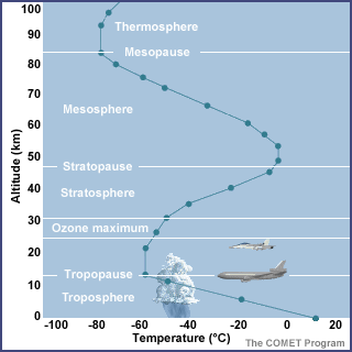
The atmosphere is divided vertically into four layers based on temperature: the troposphere, stratosphere, mesosphere, and thermosphere |
Rate
-
1
View Rating Log
-
|
|
|
|
|
|
|
|
|
|
|
Wind Formation
Wind is simply air in motion relative to the earth's surface.We normally think of the wind as the horizontal motion of the air, although air actually moves in three dimensions.The vertical component of the wind is generally quite small, except in thunderstorm updrafts.The vertical motion of air, however, is very important in determining our weather.Air that is rising cools, which may cause it to reach saturation and form clouds and precipitation.Conversely, air that is sinking warms, which causes clouds to evaporate and produce clear weather.
 | Surface maps usually have H's and L's at various locations.The H's and L's represent high and low pressure systems.On weather maps highs and lows are surrounded by lines called isobars.Isobars are lines of constant pressure; they connect every location that has the same value of pressure.When isobars are packed close together, the pressure is changing rapidly over a small distance.The closer the isobars are packed together, the stronger the pressure gradient(the rate of pressure change over a given distance.)Also, notice that (in the Northern Hemisphere) the wind blows clockwisearound a high pressure system and also slightly outward from itscenter.Around a low pressure system, the wind blows counterclockwise andslightly in towards its center.
|
Why does the wind blow?There are three forces that cause the wind to blow in the direction that it does:
1. Pressure Gradient Force
2. Coriolis Force
3. Friction
Pressure Gradient Force
 | The Pressure Gradient Force (PGF) arises due to differences in pressurewithin the atmosphere.In a physical sense, this force is trying to move air to eliminatepressure differences.The PGF causes air to flow from high pressure to low pressure.In the absence of any other forces, wind would blow directly from highto low pressure.The PGF also affects the speed of the wind.As the PGF becomes stronger (i.e. pressure changing rapidly withdistance), the wind speed increases.When looking on a surface map, strong winds would occur in locationswhere the isobars are packed close together (strong PGF). |
Coriolis Force
 | A complicated force that affects the wind is the Coriolis Force.The Coriolis Force is due to the earth's rotation.This force causes moving objects (i.e. air, planes, birds, etc) todeflect to the right of their motion in the Northern Hemisphere and tothe left in the Southern Hemisphere.The Coriolis Force is strongest near the poles and zero at the equator.In most of the atmosphere, it is nearly equal and opposite the PGF.If the PGF and the Coriolis Force are exactly equal and opposite, thewind would blow parallel to isobars, with high pressure on the right. |
Friction
 |
| The third force acting on the wind is friction.Friction becomes very important near the earth's surface because thesurface of the earth is rough.Friction is the force that causes air to slow down and spiral into lowsand out of highs.When air spirals into the low, it is converging into the low.When air converges near the surface, it is forced to rise.As air rises, it may condense and form clouds and precipitation.This is why low pressure systems are often associated with adverseweather conditions.Conversely, high pressure systems are generally associated with fairweather.When air spirals out of the high, it is actually diverging.As air diverges from the high, the air above the surface must sink inorder to replace the air that is moving away from the high.Sinking air warms and tends to evaporate any clouds that may be present. |
|
Rate
-
1
View Rating Log
-
|
|
|
|
|
|
|
|
|
|
|
Originally posted by waterboy at 24-1-2007 04:30 PM
Kebocoran pada lapisan ozon telah dikesandi kawasan Antartika pada tahun 1985, di Artik pada tahun 1987 dan sekarang diAustralia pula. CFC bukan sahaja memusnahkan lapisan ozon, molekul CFC berupayamenyerap haba 20000 kali ganda lebih baik daripada satu molekul karbondioksida. Urbanisasi Urbanisasi merupakan proses pembandaran sesebuah kawasandengan menjadikan kawasan itu kawasan perbandaran. Urbanisasi akan membawakepada pertambahan penduduk akibat imigrasi penduduk luar bandar ke bandar.Apabila terdapat banyak penduduk, kegiatan-kegiatan ekonomi berkembang, banyaktanah baru akan dibuka untuk menempatkan rumah, bangunan dan kilang.Pembinaan-pembinaan yang berleluasa akan menyebabkan pencemaran air, udara danbunyo. Penduduk lebihan yang kian bertambah pula akan mewujudkan kesesakan dankawasan setinggan. Keseimbangan ekologi semula jadi akan terganggu apabilajalanraya dan bangunan dibina di kawasan hutan yang dibuka.
kebocoran ozon bukanlah merupakan sesuatu yang statik... ia ada kembang kuncupnya... rasanya kebocoran ozon dikaw. Antartik akhir-akhir nie telah berjaya dipatch kembali.
Pada pendapat teman sekiranya kita ingin berbincang bahawa urbanisasi yang menyebabkan kebocoran ozon... point yang penting diketengahkan adalah bagaimana kawasan contohnya di Antartik & Artik (yg belum mengalami urbanisasi) boleh menyebabkan kebocoran ozon (setakat nie hanya kaw. tersebut terbabit sahaja mengalami kebocoran, kaw.2 lain mengalami penipisan sahaja) |
Rate
-
1
View Rating Log
-
|
|
|
|
|
|
|
|
|
|
|
Originally posted by waterboy at 24-1-2007 05:11 PM
The Basic Properties of the Atmosphere
In the United States, pressure is commonly expressed in millibars (mb)or inches of mercury (Hg). Meteorologists use millibars (the unit shownon weather maps), while aviation and television weather reports useinches of mercury.Atmospheric pressure is measured with a barometer, which is why it issometimes called barometric pressure.The average sea level pressure is 1013.25 mb or 29.92 Hg.
1013.25hPa or 29.92 Hg adalah mean sea level pressure bagi ISA (International civil aviation organisation's International standard atmosphere)... standard ini hanya digunakan untuk melakukan penilaian bagi aircraft performance dan calibration for some aircraft instruments... selain daripada untuk aviation 1013.25 mb tidak digunakan sebagai average for sea level pressure
[ Last edited by rudz at 24-1-2007 05:54 PM ] |
Rate
-
1
View Rating Log
-
|
|
|
|
|
|
|
|
|
|
|
Originally posted by waterboy at 24-1-2007 05:28 PM
Wind Formation
Why does the wind blow?There are three forces that cause the wind to blow in the direction that it does:
1. Pressure Gradient Force
2. Coriolis Force
3. Friction
Ini adalah pergerakan secara geostropik (basic tanpa menimbangkan daya-daya setempat/local ataupun kata lain mempertimbangkan angin yang bergerak secara horizontal)... bagi pergerakan angin untuk 3 dimensi daya-daya berikut sekurang-kurangnya perlu dipertimbangkan;
1. PGF
2. CoF
3. CeF
4. friction |
Rate
-
1
View Rating Log
-
|
|
|
|
|
|
|
|
|
|
|
|
The decreasing partial pressure of oxygen as an aircraft climbs past 10 000 |
|
|
|
|
|
|
|
|
|
|
|
Effect on aircraft instruments
The lightning discharges emit radio waves |
|
|
|
|
|
|
|
|
|
|
|
Kesan daripada St. Elmo's fire
St. Elmo's Fire
St. Elmo's fire is a plasma (i.e. a hot, ionized gas) that forms around the tips of raised, pointed conductors during thunderstorms. It is known as a corona discharge or point discharge to physicists. The few people that have had the privilege of viewing an actual St. Elmo's fire have given various descriptions. It has been seen with different physical characteristics depending on the conditions of the viewing. It could be blue to bluish-white, silent to emitting a hissing sound, and ghostly to solid.
St. Elmo's fire occurs during thunderstorms - generally after the most severe part of the storm has passed - when the air reaches a very high voltage. These conditions are necessary to accumulate a charge large enough to create the phenomenon. It is always found attached to a grounded conductor with a sharp point; the most common are masts of sailing ships, church steeples, airplane wings or propellers, or even horns of cattle. The non-attached version of St. Elmo's fire is known as Ball Lightning.
St. Elmo's Fire forms on aircraft flying through heavily charged skies, often as a precursor to a lightning strike. The glow can be seen concentrated on wing tips, antennae, the tail, nose and propeller blades when the potential difference is large enough. St. Elmo's Fire can be heard "singing" on the craft's radio, a frying or hissing sound running up and down the musical scale, according to some pilots.
A British Airways 747 flight was flying at night in the South Pacific just after a volcanic eruption of Mt. Galunggung, in western Java. St. Elmo's fire was observed extending from the engines and sparking across the instrument panel, while smoke was smelled inside the passenger cabin. In minutes, the number four engine shut down, followed quickly by the remaining three. The aircraft glided from 37,000 feet to 12,000 feet before the crew was able to restart the engines and steer for an emergency landing at Jakarta. Ash appeared as smoke as it was sucked into the air conditioning system. The static electricity created by the ash hitting the windscreen and wings had created the St. Elmo's fire. |
|
|
|
|
|
|
|
|
|
| |
Category: Belia & Informasi
|


 Post time 3-1-2007 12:50 AM
 变色卡
变色卡 Author

![Jangan Lupa Janji [Slot Tiara, Astro Ria : Ben Amir, Uqasha Senrose, Ardini Angeline Tan, Jazmy Juma Khan, Layla Sania]](https://uf.cari.com.my/forumx/mforum/block/4a/4a2b21c9ed41c68eb9df0974a2873892.jpg)


