|
|
An area of disturbed weather developed southeast of Chuuk (Federated States of Micronesia) on November 24.
Wind shear near the disturbance soon decreased, allowing the depression to organise a little.
It was designated a tropical depression by Japan Meteorological Agency on November 25, and later that day
the Joint Typhoon Warning Center started issuing warnings on the system as it moved west-northwest towards
Yap (an island in the Caroline Islands of the western Pacific Ocean) .
The depression strengthened because it was in an area of high sea-surface temperatures, and there were
distinct cloud features of anticyclonic outflow, according to the JMA.
It was upgraded to a tropical storm on the afternoon of November 26 and named Durian.
The name Durian refers to a fruit, Durio zibethinus, and was submitted to the naming list by Thailand.
However, intensification slowed down during the next day (November 27).
Current storm information:
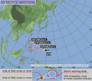
At 0300 UTC November 27, the Japan Meteorological Agency reported Tropical Storm Durian to be located
near 10.1N 140.0E, with maximum 10-minute sustained winds of 40 kt (75 km/h, 45 mph). It had a minimum
central pressure of 994 hPa, and was moving west at 10 knots.
At 2100 UTC, the Joint Typhoon Warning Center reported Tropical Storm 24W to be about
160 nm (295 km, 185 miles) east-northeast of Yap(an island in the Caroline Islands of the western Pacific Ocean),
with maximum 1-minute sustained winds of 45 knots (85 km/h, 50 mph), gusting to 55 knots (100 km/h, 65 mph).
As of: 0300 UTC November 27, 2006
Location: 10.1N 140.0E
As of 2100 UTC: 160 nm east-northeast of Yap
Winds: 40 kt (75 km/h, 45 mph) sustained (10-minute mean)
45 kt (85 km/h, 50 mph) sustained (1-minute mean)
gusting to 55 kt (100 km/h, 65 mph)
Pressure: 994 hPa
Movement: West at 10 kt
[ Last edited by redCeri^cet at 8-12-2006 04:17 PM ] |
|
|
|
|
|
|
|
|
|
|
|
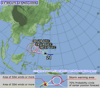
AT 2100Z 27 NOV 2006
THE CENTER OF TROPICAL STORM DURIAN WAS LOCATED NEAR
LATITUDE 11.2 DEGREES NORTH AND LONGITUDE 136.0 DEGREES EAST.
THIS IS ABOUT 175 MILES NORTHWEST OF YAP OR ABOUT 600 MILES
WEST-SOUTHWEST OF GUAM.
TROPICAL STORM DURIAN IS MOVING WEST-NORTHWEST AT 11 MPH.
DURIAN WILL CONTINUE MOVING IN THIS GENERAL DIRECTION WITH A
SLIGHT INCREASE IN FORWARD SPEED DURING THE NEXT 24 HOURS.
MAXIMUM SUSTAINED WINDS NEAR THE CENTER OF DURIAN HAVE INCREASED TO
65 MPH. DURIAN IS EXPECTED TO INTENSIFY TO A TYPHOON WITHIN THE
NEXT 12 HOURS. TROPICAL STORM FORCE WINDS EXTEND OUT AS FAR AS 75
MILES FROM THE CENTER.
Ribut Tropika "Durian" berada pada kedudukan berhampiran latitud 11.2 Utara dan longitud 136.0
Timur, kira-kira 1681 km ke tenggara Manila, Filipina pada jam 5.00 pagi 28 November 2006 dan
dijangka bergerak ke baratlaut dengan kelajuan 18 kmsj.
Ribut tropika ini berada sejauh 2272 km ke timurlaut Kota Kinabalu, Sabah; 3753 km ke timur Kota Bharu,
Kelantan dan 3896 km ke timurlaut Kuala Lumpur.
 |
|
|
|
|
|
|
|
|
|
|
|
Ribut tropika Durian landa Filipina
MANILA: Ribut tropika Durian memasuki Filipina semalam dengan pengkaji cuaca memberi amaran ia mungkin membentuk taufan besar sebelum mendarat di kepulauan berkenaan
Sehingga jam 1 pagi waktu tempatan semalam, ribut berkenaan berkelajuan 870 kilometer sejam di timur laut pulau Samar dengan kekuatan angin maksimum 95 kilometer sejam meningkat sehingga 120 kilometer sejam, kata biro kaji cuaca Filipina.
Ribut berkenaan dinamakan dengan buah tempatan Asia Tenggara bergerak mengikut arah barat laut dan dijangka tiba di Manila awal pagi Jumaat.
揑a mungkin taufan atau taufan besar sebelum mendarat, |
|
|
|
|
|
|
|
|
|
|
|
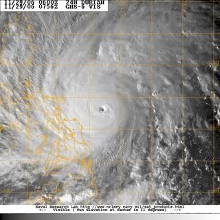
Durian Becomes a Typhoon - Philippines Threatened
Durian is now a typhoon making its way across the Philippine Sea. As of late Tuesday morning, EST,
Typhoon Durian held highest sustained winds of 75 mph around a center that was 690 miles to the
east-southeast of Manila, Philippines; it was moving westward at 17 mph.
Durian is forecast to strengthen markedly while on a heading generally to the west-northwest
through the end of the week. On its projected path, Durian would hit the northern Philippines' island
of Luzon as a powerful typhoon late Friday to Saturday. |
|
|
|
|
|
|
|
|
|
|
|
ni bukan dapat Durian Runtuh....
[ Last edited by redCeri^cet at 6-12-2006 09:16 AM ] |
|
|
|
|
|
|
|
|
|
|
|
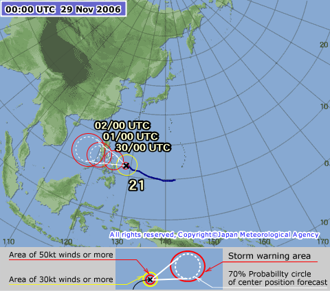
Typhoon Durian
As of: 0000 UTC November 30, 2006
Location: 13.4N 124.6E
As of 0300 UTC: 220 nm East-South East of Manila
Winds: 90 kt (165 km/h, 105 mph) sustained (10-min mean)
135 kt (250 km/h, 155 mph) sustained (1-min mean)
gusting to 165 kt (305 km/h, 190 mph)
Pressure: 940 hPa
Movement: westward at 7 kt
Moving west to west-northwestward, Durian intensified slowly.On November 28, both the JMA (Japan Meteorological Agency) and JTWC
(Joint Typhoon Warning Center) upgraded it to a typhoon as it continued to track towards the Philippines.
A quick bout of intensification occurred on November 29, causing the JMA to upgrade the storm to 100 knots in wind intensity,
and the JTWC to give it a Dvorak classification of 6.5 (127 kt) in a satellite fix.
In 6 hours, Durian intensified from 90 kt 1-minute sustained winds to 125 kt winds.
The JTWC then forecasted a direct hit over Metro Manila later that day when it upgraded the storm to a super typhoon.
PAGASA (Philippine Atmospheric, Geophysical and Astronomical Services Administration) raised Public Storm Warning Signal 4,
its highest warning level, for the third time in 2006 over Catanduanes, Albay, Camarines Norte and Camarines Sur.
Durian began to gradually weaken as it approached land. |
|
|
|
|
|
|
|
|
|
|
|
AMARAN ANGIN KENCANG DAN LAUT BERGELORA
Super Taufan "Durian" berada pada kedudukan berhampiran latitud 13.5 darjah Utara dan longitud 124.0 darjah Timur,
kira-kira 407 km ke tenggara Manila, Filipina pada jam 11.00 pagi 30 November 2006 dan dijangka bergerak ke barat dengan kelajuan 17 kmsj.
Sehubungan ini, angin kencang barat daya 40-50 kmsj dan laut bergelora dengan ombak mencapai ketinggian 3.5 meter
dijangka berlaku di perairan Sabah mulai hari Khamis (30 November 2006) hingga hari Isnin (4 Disember 2006).
Keadaan angin kencang dan laut bergelora yang sama juga dijangka berlaku di Perairan Sarawak dan pantai timur Semenanjung
Malaysia mulai Sabtu (2 Disember 2006) hingga hari Isnin (4 Disember 2006). |
|
|
|
|
|
|
|
|
|
|
|
200 korban Taufan Durian
MANILA: Sekurang-kurangnya 200 orang terbunuh dan berpuluh-puluh lain hilang selepas Taufan Durian melanda Filipina semalam.
Taufan yang keempat terbesar melanda negara itu membawa angin kencang selaju 265 kilometer sejam, menyebabkan banjir kilat selain membawa banjir lumpur daripada debu lahar gunung berapi.
Setiausaha Kesihatan, Francisco Duque memetik laporan, 200 kematian yang belum disahkan, manakala Ketua Pertahanan Awam Glen Rabonza berkata, sebanyak 200 beg mayat dihantar ke zon bencana atas permintaan pegawai wilayah.
Setakat ini 146 orang disahkan maut dan lebih 80 orang dikhuatiri terperangkap manakala 16 yang lain hilang, kata Richard Gordon, ketua Palang Merah Kebangsaan Filipina.
Helikopter digunakan untuk membawa bantuan termasuk pemancar bergerak ke kawasan yang terjejas teruk akibat terputus bekalan elektrik dan talian telefon. Pegawai menganggarkan ribut berkenaan menjejaskan kira-kira 22,000 penduduk.
揚asukan penyelamat terpaksa menyelamatkan penduduk yang terpaksa duduk berjam-jam lamanya di atas bumbung, |
|
|
|
|
|
|
|
|
|
|
|
Korban Taufan Durian lebih 400
PADANG: Penyelamat Filipina semalam terpaksa membersihkan sampah sarap untuk mencari mayat di dalam lumpur yang menenggelamkan perkampungan di kaki gunung ketika angka kematian dan hilang akibat taufan kuat sudah melebihi 400 orang dengan hampir 300 lagi hilang.
Rumah di sepanjang Sungai Yawa di Padang, kira-kira 10 kilometer dari Legazpi, ibu negeri wilayah Albay yang paling teruk terjejas, ditenggelami lumpur setebal 1.5 meter dengan cuma bumbung yang kelihatan.
Separuh daripada tiang gol setinggi 3.5 meter di pasang bola sepak berhampiran ditenggelami sampah sarap dari gunung berapi Mayon.
Pejabat Pertahanan Sivil melaporkan angka rasmi korban kini 208 dan 261 lagi dipercayai mati manakala 82 yang lain cedera. Pegawai bimbang angka kematian akan meningkat apabila banyak lagi mayat, sebahagiannya cedera teruk ditimpa batu besar yang dibawa arus lumpur, digali keluar.
Di Padang saja, 28 mayat ditemui dan diambil gambar untuk dikenal pasti oleh saudara mara, kata pembantu kanan Datuk Bandar, Luis Bello.
Selama hampir tiga jam tengah hari Khamis lalu, runtuhan lumpur mengalir ke seluruh lurah Mayon, menumbangkan pokok, meranapkan rumah dan menenggelamkan penduduk. Keseluruhan kampung kecil musnah.
Upacara pengebumian besar-besaran dijangka bermula semalam. Kematian lain turut dilaporkan di daerah Bicol, kira-kira 340 kilometer ke tenggara Manila.
揙perasi mencari diteruskan buat masa ini. Angka kematian mungkin bertambah ketika usaha diteruskan. Pengedaran barangan bantuan dapat dibuat kerana cuaca agak baik hari ini.
揝etiap sudut wilayah itu terjejas. Ia kemusnahan langsung. Tidak pernah dalam sejarah kami melihat air melimpah seperti ini. Hampir setiap kawasan kediaman dibanjiri, |
|
|
|
|
|
|
|
|
|
|
|
Northern Peninsular Malaysia
The Typhoon "DURIAN" are forecasted to move southwestward - along the Vietnam coastline while weakening after hit land.
Then, it's expected to slightly intensify when it enter the Gulf of Siam, and then move eastward to southern
Thailand/ northern peninsular region (Perlis, Kedah, Penang and northern Kelantan) might be affected by its close encounter.
[ Last edited by redCeri^cet at 7-12-2006 08:55 PM ] |
|
|
|
|
|
|
|
|
|
|
|
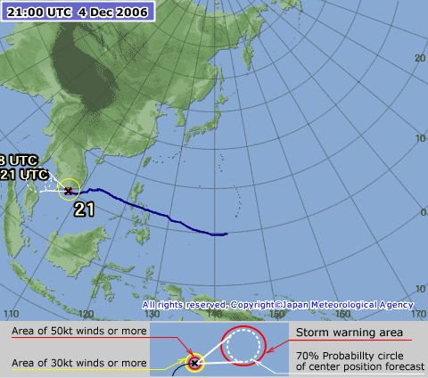
AMARAN HUJAN, ANGIN KENCANG DAN LAUT BERGELORA
Ribut Tropika "Durian" berada pada kedudukan berhampiran latitud 10.2 darjah Utara dan longitud 107.7 darjah Timur,
kira-kira 176 km ke tenggara Ho Chi Minh City, Vietnam pada jam 05:00 pagi 05 Dis 2006 dan dijangka bergerak ke baratdaya
dengan kelajuan 24 kmsj.
Ribut ini dijangka akan mulai merentasi Teluk Thailand pada malam 05 Disember 2006 sehingga malam 06 Disember 2006.
Sehubungan ini, hujan sederhana kadangkala lebat berserta dengan angin kencang dijangka berlaku di kebanyakkan
tempat di negeri Kelantan,Terengganu, Kedah dan Perlis dalam tempoh tersebut.
Amaran Angin Kencang dan Laut Bergelora Kategori Kedua yang dikeluarkan pada jam 8:00 petang 2 Disember 2006
ditingkatkan kepada Kategori Ketiga bagi perairan Pantai Timur Semenanjung Malaysia, Sabah dan Sarawak.
Angin kencang baratlaut ke baratdaya 50-60 kmsj dan laut bergelora dengan ombak mencapai ketinggian 5.5 meter
di perairan Pantai Timur Semenanjung Malaysia, Sarawak dan Sabah dijangka berterusan sehingga hari Rabu (6 Disember 2006).
Keadaan angin kencang dan laut bergelora ini adalah berbahaya kepada semua aktiviti perkapalan dan pantai termasuk
menangkap ikan dan perkhidmatan feri.
[ Last edited by redCeri^cet at 5-12-2006 09:24 AM ] |
|
|
|
|
|
|
|
|
|
|
|
Typhoon Durian not likely to hit Malaysia
PETALING JAYA: Typhoon Durian is weakening and is not expected to land in Malaysia.
As of 5pm yesterday, it was approximately 200km south-west of Ho Chi Minh City, Vietnam, and is expected to move in a south-westerly direction at a speed of 28kph.
However, the Meteorological Services Department has warned of danger to beach and shipping activities in several areas in the northern part of the peninsula due to bad weather and rough seas in the wake of the typhoon.
Wind speeds of 50kph to 60kph and waves of up to 4.5m are expected in the coastal areas of Kelantan, Terengganu, Perlis, Kedah and Penang until Friday.

READYING FOR THE STORM: A row of fishermen? boats berthed at the Tok Bali port in Kelantan on Tuesday. Residents and fishermen along the coast have been placed on standby for evacuation.
Meanwhile, all residents living along the coast in Kelantan have been placed on standby for evacuation due to torrential rains and strong winds brought by the typhoon.
A spokesman at the state operations centre said residents and fishermen in Sabak, Tok Bali, Pantai Semerak, Pantai Irama and Pantai Seri Tujuh had been informed of possible evacuation.
This follows a warning of worsening weather conditions due to the effects of the typhoon, which had earlier lashed the Philippines and Vietnam.
In a related development, Kelantan police marine commander Deputy Supt Abdul Salam Abdul Halim said all fishermen's associations had been informed of the rough weather.
?owever, I was told by most fishermen that they are used to such weather, which is part of the monsoon season. Nevertheless, they are taking all precautions,? he said.
DSP Abdul Salam said marine police had placed its vessels on standby for rescue and evacuation work in case of floods.
In Kuala Terengganu, a 1km stretch of coast in Tanjung has eroded, triggering panic among residents that the typhoon was heading their way.
Restaurateur Lau Fook Khoy, 58, said she feared that the typhoon could cause further erosion.
?he soil along the affected stretch is weakening and the situation could become worse due to the strong waves,? she said yesterday.
Terengganu Health, Unity, Consumer Affairs and Environment Committee chairman Toh Chin Yaw assured the people that the state government had taken all precautionary measures to prevent further erosion.
?e also anticipate that the typhoon will not hit Terengganu due to its travelling pattern,? he added. |
|
|
|
|
|
|
|
|
|
|
|
Tropical storm Durian hit Vietnam
At least 55 people died and 26 were missing when severe tropical storm Durian hit Vietnam, destroying houses
and sinking boats after wreaking deadly havoc in the Philippines, officials said.
The storm was downgraded from the powerful typhoon that left more than 1,200 people dead or missing when
it triggered a mudslide in the Philippines.
Twenty-eight people died and sixteen were missing in Ba Ria-Vung Tau, east of Ho Chi Minh City, in a province
which has tourist resorts and offshore oil rigs, said Nguyen Ngoc Loc of the flood and storm control committee.
In the Mekong Delta province of Ben Tre, 17 people were reported dead and there were fears of more
casualties in the poor and geographically flat region, where many people live in wooden huts or on house boats.
Durian made landfall in southern Vietnam overnight, with lashing rains and wind speeds of nearly 120 kilometres
(75 miles) per hour, smashing thousands of houses, uprooting trees and bringing down power lines.
It sank more than 800 boats moored on a remote South China Sea island before brushing Ho Chi Minh City, the
country's largest city, and heading southwest across the Mekong Delta.
The Vietnamese island of Phu Quy, 250 kilometres (150 miles) east of Ho Chi Minh City, the former Saigon,
suffered heavy damage as the storm lifted the roofs off more than 1,000 houses, but there were no reported
casualties.
Two people were reported dead in Tien Giang province, two were missing and 20 were injured, said flood and storm
control committee official Nguyen Duc Thinh.
"More than 6,600 houses were damaged and 26 schools unroofed," he said, adding that authorities had evacuated
nearly 13,000 people.
Two more people were killed by falling trees in Binh Thuan province, three people died in Phu Yen province, and
one was killed in Vinh Long, with three more missing, officials said.
Meteorologists had expected the storm to hit further north, where troops had helped Monday in evacuating tens of
thousands of people, but preventive action in the provinces further south appears to have averted a worse disaster.
"We had evacuated 3,500 people," said Tran Thi Luan, head of the Ben Tre provincial flood and storm control committee.
"If the evacuation had not happened, the toll would have become much higher. The storm was really strong."
Wind speeds slowed to 100 km/h in the afternoon, when Luan said "the weather seems to be better, but we do not
dare yet tell people that the storm is over, because this is a really complicated storm."
Ho Chi Minh City escaped the worst as the eye of the storm passed to the south. Vietnam television, however, said
two people were killed in the country's business capital.
More than 8,000 people were evacuated from high-risk areas, but there were still fears for some people missing.
Officials in the seaside resort of Nha Trang said they had no immediate reports of casualties.
[ Last edited by redCeri^cet at 6-12-2006 12:20 PM ] |
|
|
|
|
|
|
|
|
|
|
|
|
Setakat ni kat luar tu dah mula berawan, angin tak bertiup (calm b4 the storm?)...tengok la malam kang camne |
|
|
|
|
|
|
|
|
|
|
|
Cuaca buruk di utara
KOTA BHARU: Walaupun ribut tropika Durian dijangka tidak melanda Malaysia, beberapa kawasan di utara Semenanjung diramal mengalami cuaca buruk dengan laut bergelora.
Bahagian Kajicuaca Lautan dan Oseanografi, Jabatan Meteorologi dalam satu kenyataan berkata, keadaan itu menyebabkan angin kencang kadang kala mencapai kelajuan 50 hingga 60 kilometer sejam dan ombak dengan ketinggian 4.5 meter di perairan Kelantan dan Terengganu yang dijangka berterusan hingga hari ini.
Jabatan itu berkata, keadaan angin yang sama dengan ombak setinggi 4m pula dijangka berterusan di perairan Perlis, Kedah dan Pulau Pinang sehingga esok.
?ngin kencang 40 hingga 50 km/j dengan ombak mencapai ketinggian 3.5m dijangka berterusan di perairan Pahang, Johor Timur, Sarawak dan Sabah Timur sehingga Khamis,? kata jabatan itu dalam amaran kategori kedua dikeluarkan pada jam 7 pagi semalam.
Jabatan itu berkata, keadaan itu berbahaya kepada semua aktiviti perkapalan dan pantai.
Katanya, lekukan tropika Durian kini masih berada di Teluk Siam dan akan menjadi semakin lemah dalam masa 24 jam. Lekukan tropika itu bergerak ke arah barat merentasi Teluk Siam dengan kelajuan 20 km/j dan melintasi Selatan Thailand petang semalam.
?elajuan angin maksimum 60km sejam dijangka berlaku berhampiran lekukan tropika berkenaan,? kata jabatan itu.
Sementara itu, di Kota Bharu, sekumpulan nelayan dari Bachok menempuh ribut dan hujan lebat, dipercayai ada kaitan dengan Taufan Durian, ketika keluar menangkap ikan pagi semalam.
Dalam kejadian jam 10 pagi, 10 bot nelayan sedang memukat pada kedudukan tiga batu nautika dari pantai apabila tiba-tiba mereka dilanda hujan lebat dan angin kencang.
Pengerusi Persatuan Nelayan Kawasan (PNK) Bachok, Mohd Saripuddin Ishak, berkata nelayan terbabit dengan pantas menarik pukat yang baru dipasang sebelum pulang ke pangkalan walaupun tangkapan sedikit.
?ereka tidak berani mengambil risiko kerana kita percaya ia tempias Taufan Durian yang sebelum ini melanda Filipina,? katanya di sini, semalam. |
|
|
|
|
|
|
|
|
|
|
|
Thursday December 7, 2006
Threat from Durian eases
PETALING JAYA: Typhoon Durian has crossed the Isthmus of Kra about 450km north of Malaysia and is heading towards the Andaman Sea.
The Meteorological Services Department reports that with the typhoon heading further away from Malaysia, the threat of it causing damage is reduced, but wind speeds of 30kph-40kph and waves of up to 4m are expected to hit the coastal areas of Perlis, Kedah, Langkawi and Penang today.
In Kelantan, villagers along the coast of Kuala Besar and Pantai Sabak are still preparing for strong winds and high waves in the aftermath of the typhoon.
The villagers were seen hammering nails into planks as well as strengthening their rooftops, while fishermen were mooring their trawlers and sampans at safer areas.
Many also did not go out to sea following warnings of stormy seas.
According to fisherman Din Medan, 46, the wind was strong when he returned to Kuala Besar but was not strong enough to cause his vessel to overturn.
A spokesman with the state operations centre said all agencies were on standby for possible strong winds and torrential rain.
State Agriculture committee chairman Dr Nik Mazian Nik Mohamed urged everybody to pray for good weather as the state was currently encountering the monsoon season, which can be worsened by the effects of a typhoon.
In Terengganu, more policemen will be on duty in the next few days to help residents affected by Durian.
State police chief Senior Asst Comm (I) Acryl Sani Abdullah said 3,000 personnel from several departments had been pooled together to prepare for any eventuality.
He said eight operations centres had been set up.
SAC Acryl said personnel on leave could be recalled, depending on the situation.
He said police would work closely with the relevant departments in rescue work.
In Kedah, Mentri Besar Datuk Seri Mahdzir Khalid said the state government was not taking any chances and had directed all 11 district offices to be on the alert.
He said announcements would be made through local radio station Kedah fm if the typhoon intensified.
?e want those staying along the coast and involved in marine activities to be on full alert, although reports stated that the typhoon was slowing down,? he told newsmen yesterday |
|
|
|
|
|
|
|
|
|
|
|
Taufan Durian: 70 terbunuh di Vietnam
HANOI 7 Dis. |
|
|
|
|
|
|
|
|
|
|
|
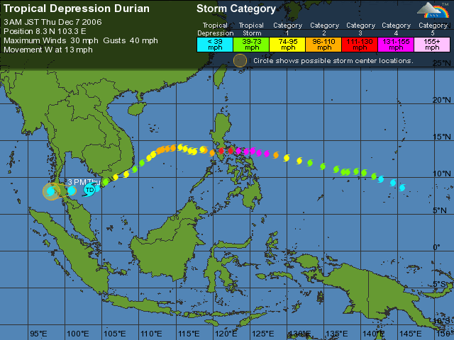
Typhoon Durian Track
November 24 - December 5, 2006
From West Pacific Ocean to South China Sea --> Gulf of Thailand --> Andaman Sea (North Indian Ocean basin)
 |
|
|
|
|
|
|
|
|
|
| |
Category: Belia & Informasi
|


 Post time 27-11-2006 03:17 PM
 变色卡
变色卡 Author
 Post time 29-11-2006 07:18 AM


