|
View: 3901|Reply: 11
|
[HISTORY OF GEOGRAPHY]: CHOMOLUNGMA, SAGARMATHA DAN EVEREST
 [Copy link]
|
|
|
Sebagai seorang pakar mathematik yang computate pelbagai pengiraan metahmatic yang sukar di bawah department of Great Trigonometrical Survey of India, Radhanath Sidkar mendapati bahawa bukanlah Gunung Kangchenjunga merupakan gunung tertinggi didunia; sudah berapa lama ianya dianggap sebagai yang tertinggi.
Radhanath bertungkus lumus pada tahun 1852 meng-computate hal ini, ''Puncak XV'' ini namun ia tetap mengeluarkan ukuran 29,000 kaki. Boss nya, Col Andrew Waugh sangat tidak berpuas hati kerana ianya tepat2 29,000 kaki; beliau tidak mahu ianya dianggap sebagai agak-agakkan sahaja. Radhanath lalu mengcomputate secara matematik, dari 6 tempat berbeza di Utara India.. namun hasilnya sama, 29,000 kaki. Sebagai seorang computer di pejabat itu, mereka akur dengan ukuran Radhanath ini. Beliau dinaik pangkat menjadi Ketua Computer di jabatan itu.
Maka, jelaslah, ''Puncak XV'' ini memang lebih tinggi dari Kangchenjunga. Maka, apakah akan dinamakan ''Puncak XV'' ini? Mula2 sekali nama yang paling utama tentulah ''Sagarmatha'', mengikuti tradisi Nepal masa itu. Satu lagi, ialah ''Chomolungma'', dari tardisi orang2 Tibet. Ini lah nama yang paling sesuai, dan menamakannya dengan nama2 ini adalah sangat sesuai pula dengan style yang dibawa oleh bekas boss lama Surveyor General of Inida, iaitu Col Sir George Everest, iaitu menamakan apa2 pun di India pada masa itu, dengan nama tempatan.
Tetapi Col Waugh, Surveyor General of India pada masa itu, berkeras untuk menakannya dengan nama yang 'senang untuk dieja', dari segi Colonial British; lalu menamakan nya Everest. Beliau juga menyatakan dalam laporannya bahawa tinggi ''Peak XV'' ialah 29,002 kaki, untuk mengelak dituduh orang sebagai agak-agakkan sahaja. Maka, kekallah nama gunung yang bersejarah itu, dengan nama seorang yang tidak pernah pun melihat gunung itu sendiri, tidak terlibat dalam mengukurnya dan tidak pula setuju dengan penamaannya.
NB: di Nepal hari ini, Peak XV ini tetap dipanggil Sagarmatha.
|
This post contains more resources
You have to Login for download or view attachment(s). No Account? Register
x
Rate
-
1
View Rating Log
-
|
|
|
|
|
|
|
|
|
|
|
Pernah naik ke Simla, India...cantik betul Banjaran Himalaya  |
|
|
|
|
|
|
|
|
|
|
|
iya? awak pernah tgk Himalaya?
breathtaking tak?
Karakoram rasanya dekat2 situ juga
also K2.
dan, everest kdg2 org tak nmpk, betul ke?
|
|
|
|
|
|
|
|
|
|
|
|
ipes2 replied at 8-1-2021 07:08 AM
iya? awak pernah tgk Himalaya?
breathtaking tak?
Karakoram rasanya dekat2 situ juga
Breathtaking...ada snap pic...nanti cari... |
|
|
|
|
|
|
|
|
|
|
|
ye ke..
himalaya ni bkan macam Gunung Fujiyama tau.. lalu2 je boleh nampak.
ianya terletak padanya high elevation to start with
|
|
|
|
|
|
|
|
|
|
|
|
Ye le, Simla tu high place...nanti taruh gambo, kome 
|
|
|
|
|
|
|
|
|
|
|
|
ipes2 replied at 8-1-2021 07:50 PM
ye ke..
himalaya ni bkan macam Gunung Fujiyama tau.. lalu2 je boleh nampak.
ianya terletak padan ...
Pokchik Google- Shimla is the capital of the northern Indian state of Himachal Pradesh, in the Himalayan foothills...
Korek2...jumpa dah gambo |
This post contains more resources
You have to Login for download or view attachment(s). No Account? Register
x
Rate
-
1
View Rating Log
-
|
|
|
|
|
|
|
|
|
|
|
ohh ini Shimla
depa ni lasak la sebab hidup dekat harsh terrains mcm himalayas tu
|
|
|
|
|
|
|
|
|
|
|
|
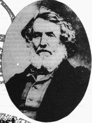
Colonel Sir George Everest CB FRS FRAS FRGS
|
This post contains more resources
You have to Login for download or view attachment(s). No Account? Register
x
Rate
-
1
View Rating Log
-
|
|
|
|
|
|
|
|
|
|
|
ohh begini rupa dia ya..
sy tak pernah terlintas untuk cari and view
terima kasih cik seri
|
|
|
|
|
|
|
|
|
|
|
|
Bio dia...
SIR GEORGEEVEREST AND SURVEY OF INDIA by Mary M. Root
 The highest mountain in the world isnamed for a surveyor, Colonel Sir George Everest. It is a fitting tributeto the man who, for more than twenty-five years and despite numerous hardships,prevailed in surveying the longest are-of-the-meridian ever accomplished at thetime. The Great Trigonometrical Survey India, begun at Cape Comorin in1806 by William Lambton, would then run almost 2,400 kilometers north to theHimalayas, extending over 20 along the meridian. During this tremendousundertaking, Everest was relentless in his pursuit of accuracy. To thatend, he made countless adaptations to the surveying equipment, methods, andmathematics in order to minimize problems specific to the Great Survey: immense size and scope, the terrain, weather conditions, and the desiredaccuracy. The highest mountain in the world isnamed for a surveyor, Colonel Sir George Everest. It is a fitting tributeto the man who, for more than twenty-five years and despite numerous hardships,prevailed in surveying the longest are-of-the-meridian ever accomplished at thetime. The Great Trigonometrical Survey India, begun at Cape Comorin in1806 by William Lambton, would then run almost 2,400 kilometers north to theHimalayas, extending over 20 along the meridian. During this tremendousundertaking, Everest was relentless in his pursuit of accuracy. To thatend, he made countless adaptations to the surveying equipment, methods, andmathematics in order to minimize problems specific to the Great Survey: immense size and scope, the terrain, weather conditions, and the desiredaccuracy.
When Everest "inherited" theposition in 1823, the equipment originally employed by Lambton consisted of one36" theodolite manufactured by London instrument maker Cary, a zenithsector by Jesse Ramsden, a Ramsden 100 foot steel chain, and achronometer. The Cary theodolite, weighing over one thousand pounds, hadbeen damaged in two separate mishaps, and was badly in need of repair. Themicrometer screw on the zenith sector was worn out, and the steel chain had notbeen calibrated in twenty-five years. To further complicate matters,Everest became so dangerously ill that he could not carry on with the Survey,and work was suspended.
England was the solution to theseproblems. In November of 1825, Everest returned to England, bringing withhim the mathematical observations and calculations for the Great Arc thusfar. For the next five years he worked on improvements for the survey andcompiled an account of the work achieved between the parallels of 18 degrees 03'and 24 degrees 07'. Everest spent a great deal of time in the workshop ofinstrument-makers Troughton and Simms, where an additional 36" theodolite,a new zenith sector, and six small theodolites were under construction. Ofthe last, Everest wrote: "I have devoted some consideration to theimprovement of the common theodolite which is both cumbersome and more expensivethan need be and after frequent examination of all the best devices I could meetwith in the shape of the various makers in London, Mr. Simms has at mysuggestion designed an instrument which contains all the useful parts of the oldconstruction, is quite free from superfluous apparatus and is cheaper byone-fourth...The model has only a 5 inch diameter but the principle is soperfectly applicable to all instruments for secondary triangles that I shouldrespectfully recommend the propriety of adopting this as the Honorable EastIndia Company's form for all small theodolites not exceeding 12 inches diameterand preserving on all future occasions the strictest uniformity."
The next issue Everest addressed wasthe measuring of distances. He learned of Col. Colby's work withcompensating bars on the Irish Survey, and visited him there in 1829. Being very much impressed with Colby's system, he acquired a double set of sixbars for the Great Trigonometrical Survey, and practiced with them at Greenwich.
At the same time, Everest produced aclever document which summarized the repair and replacement needs of the Survey,showing that the most cost-effective solution was to have an instrument makerplaced in India. His request was granted, and Henry Barrow was appointedto the job. Later, in India, it was Barrow who laboriously repaired thedamaged Cary theodolite, earning his praise from Everest: "I must dothat artist (Barrow) the justice to say that for excellence of workmanship,accuracy of division, steadiness, regularity, and glibness of motion, and thegeneral neatness, elegance and nice fitting of all its parts, not only were myexpectations exceeded but I really think it is as a whole as unrivalled in theworld as it is unique."
In June of 1830, George Everestreturned to India, this time as Surveyor General, in addition to his post assuperintendent of the Great Trigonometrical Survey. During the first yearhe spent little time on field work, as he organized general mappingsurveys. Everest's first work on the Arc was to create a baseline nearDehra Dun using the Colby compensating bars. The 39,183.783 foot baselinewas meticulously surveyed, using every precaution to safeguard itsaccuracy. He then connected the Dehra Dun baseline to the Sironj baseline,a distance of over 400 miles, using a triangulation gridiron. This wasacross a vast plain, which necessitated the construction of masonry towers,designed by Everest, most of them 50 feet high. The great theodolite wasthen hoisted to the top, and Everest performed and recorded theobservations. By day, heliotropes were placed on distant points,reflecting bright flashes of sunlight towards the survey towers. On dayswhen refraction became a problem, observations were taken at night, using anIndian version of the reverberatory lamp which could be seen for thirty miles,and sometimes by using cylindrical blue lights whose visible range could exceedfifty miles. Transportation was interesting; a typical foray included 4elephants for the tiger-wary principals, 30 horses for the military officers,and 42 camels for supplies and equipment. The 700 or so laborers traveledon foot. Progress was steady; by May of 1836 half of the gap betweenSironj and Dehra Dun had been completed, and the rest was completed thefollowing season.
Everest next turned his attention toastronomical observations throughout the arc of meridian, especially atKalianpur (24 degrees 07'). Unfortunately, ill health prevented him fromcompleting this task, so it was Andrew Waugh who stepped in to finish the job,including re-measuring the Bidar baseline with the Colby compensatingbars. The subsequent error of closure between the observed and computedlength of the Bidar base, after 425 miles and 85 triangles from Sironj, was 0.36feet in a line length of 41,578 feet.
By 1841, twenty-three years had passedfrom the time Everest had first begun work on the Great Arc. It would takehim two more years to complete the computations, and compile the results beforehe retired and returned to England.
In 1848, he was awarded high honors bythe Royal Astronomical Society. In making the presentation, Sir JohnHerschel said: 'The Great Meridianal Arc of India is a trophy of which anynation, or any government of the world would have reason to be proud, and willbe one of the most enduring monuments of their power and enlightened regard forthe progress of human knowledge."
POSTSCRIPT:
It is not known whether or not GeorgeEverest ever laid his eyes on the great mountain that bears his name, but histriangulation network was extended and used to locate the summit by AndrewWaugh, Everest's successor as Surveyor General in India. Waugh'sadmiration of Everest's achievements led to the naming of " eak XV" inthe Himalayas. After its discovery by his team, Waugh, wrote:"...here is a mountain most probably the highest in the world without anylocal name that I can discover...", so he proposed "...to perpetuatethe memory of that illustrious master of geographical research...Everest." eak XV" inthe Himalayas. After its discovery by his team, Waugh, wrote:"...here is a mountain most probably the highest in the world without anylocal name that I can discover...", so he proposed "...to perpetuatethe memory of that illustrious master of geographical research...Everest."
|
Rate
-
1
View Rating Log
-
|
|
|
|
|
|
|
|
|
|
|
jazakillah
sy pon tak baca yg sedetail ini
well done cik seri
|
|
|
|
|
|
|
|
|
|
| |
|


 Post time 3-1-2021 05:48 AM
 变色卡
变色卡 Post time 7-1-2021 12:30 PM
 Author